The East Anglian Waterways Association
Promoting access to the navigations of East Anglia for all
| Email EAWA |

The East Anglian Waterways Association Promoting access to the navigations of East Anglia for all |
|
| Home | About Us | Latest News | East Anglian Waterways | The Easterling | Join Us | Directors | NW & Dilham | Work Party | Links | Forum |
We think the confusion over just where the Stamford Canal starts and finishes can be overcome by our choosing our nomemclature more carefully.It was to overcome this that Stamford Corporation was granted its Royal Charter in 1621. The corporation was empowered, firstly, to make an artificial cut, separate from the river, from Hudds Mill some six and a half miles through ten locks down to Market Deeping, where the cut was to rejoin the river. And secondly to make the river navigable for a further two and a half miles southwards from Market Deeping through two locks. From there the river was presumably in a reasonable navigable condition. Hence I have always regarded the Stamford Canal as stopping at Market Deeping where it rejoined the Welland to the west of the main crossroads in the town - i.e. downstream of Market Deeping Mill and lock and upstream of Market Deeping Bridge. How this junction came to be known as Tongue End, very close to Market Deeping town center, (Lot 21 1865 auction) I have no idea, but perhaps the name derives from the tip of land where the canal and river met at a fairly acute angle being shaped like a tongue. To my mind we could perhaps overcome the confusion by referring to the whole
nine-mile navigation as the Stamford Navigation, of which the Stamford
Canal formed an important part. This also helps understand the nonsense of the head of the navigation being quoted as Hudds Mill, where the canal section began, whereas the main wharves were on the river on the way up to the town bridge. |
A walk from Tallington to West Deeping along the route of the Stamford Canal
or as the locals called it 'The Boaty River' with Ken Otter turned out to be a
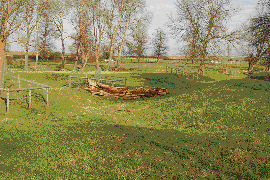
very interesting day. The remains of Tallington Village lock structure. Now kept
tidy as a nice garden.
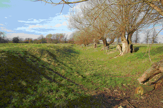
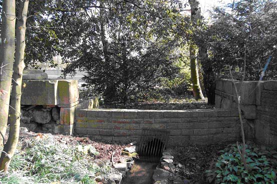
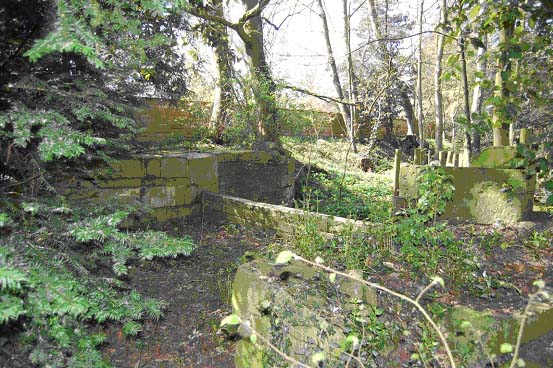
 The first big surprise for me was a winding hole in Tallington. Once Ken pointed out its position, its shape can clearly be seen in the grass alongside the canal bed.  The path runs along the canal bed, and the bench is situated just about in the middle of the winding hole. The next feature is the railway crossing. Today very little of the canal can be seen at the crossing. Ken told me that the rails on the Eastern side crossed the canal just below the Tallington Horse Holmes lock. They had to curve the track bed round the end of the lock to avoid the need of embankment to cross the canal at the higher level above the lock. Later, more tracks were laid on the Western side over the top of the lock. Lock structure likely still remains buried under the track bed. The tunnel is still under the Eastern rails, though filled in. East of the railway the canal bed progresses to West Deeping with a mysterious curve through the field. We couldn't see any obvious reason for the curve. Possibly to avoid marshy ground, or following the contour to avoid embankments. (More study needed here) In West Deeping we found the canal watered before it disappears into private gardens. Most of Structure remains of the St Andrews lock. 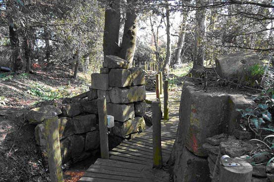 It has been rearranged far from how it was originally.
 The bottom gate
structure is pretty much complete. Below this lock was a basin, the tennis
courts are built over what locals call a 'Winding Basin'.
 The tail of the opening into St Andrews lock has odd sides, possibly to allow boats easier entry from the basin .
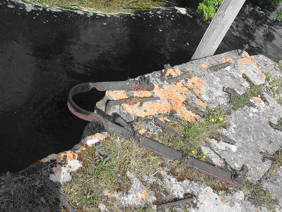
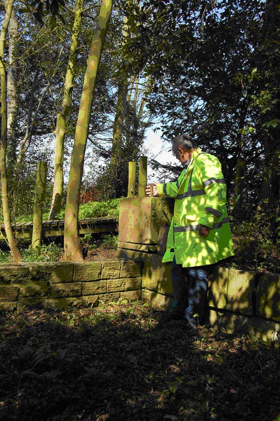 Ken, examining the ironwork on St Andrews Lock .The road in West Deeping was crossed by ford with a footbridge over the canal. Here there is evidence of a feeder that supplied an arm. The arm is clearly visible cutting across the field to the East of the road terminating at the building, which is at the side of what looks to be two derricks. The derricks poles don't look very original. They look to be positioned where the arm ends, exactly where loading, unloading would have taken place. 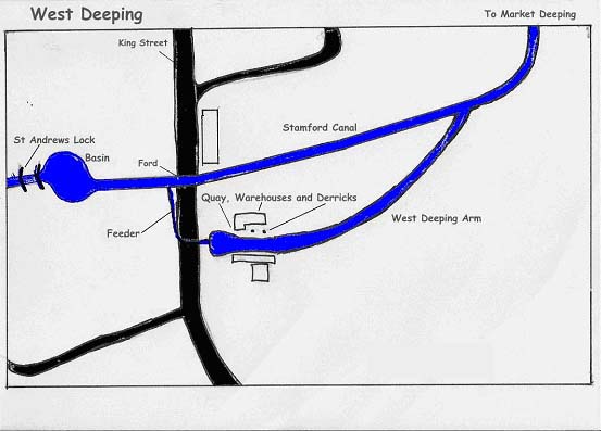 Many thanks to Ken for taking the time to show me the remaining features. And for sharing his knowledge about the canal. 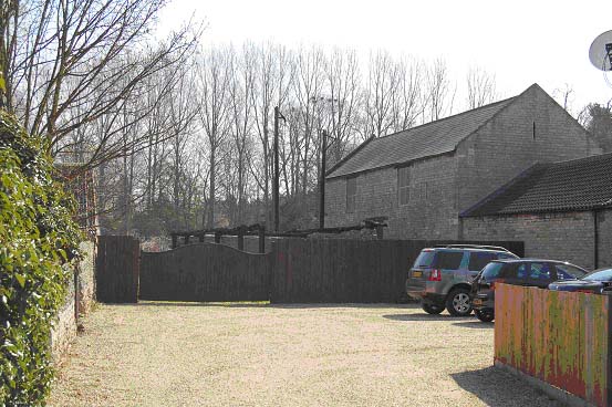 |
| Steve Machin, who wrote this article, would be
pleased to hear from anyone who would like to share information on the Bourne
Eau, Stamford Canal and associated waters. Please email him on |
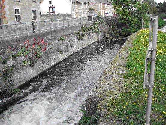
The Stamford Canal.In the Sixteenth century the people of Stamford submitted a petition to the crown asking permission to improve the navigation of the river Welland between Stamford and Market Deeping by creating a new cut to bypass the watermills. A 'Navigation Act' was signed by Queen Elizabeth 1 in 1571.After a few false starts the canal construction was started by Daniel Wigmore in 1664 at a cost of £5000. Its completion date is not exactly known but traffic was reported to pass up and down in 1673, some 100 years before the Bridgewater canal! The canal was six and a half miles long and twelve locks completed the navigation. The ten locks on the canal were turf sided with stone abutments. The other two locks on the River Welland in Deeping St James had stone chambers to withstand the faster flow of the river when in flood. Some excavation on the canal bed near Stamford revealed that blue clay puddling was used to line the canal. |
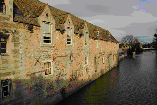
Warehouse on the riverside
near the Stamford Town Bridge
. 
Stamford town bridge.
Possibly the upper limit of the navigable Welland.
Boats would leave the Welland and almost immediately be in the first lock.
 |
The river Gwash was
crossed by the canal here. This weir is in the Gwash bypass channel.
A sluice
was in the river channel.
Together the weir and sluice controlled the river
level so the canal could cross on the same level.
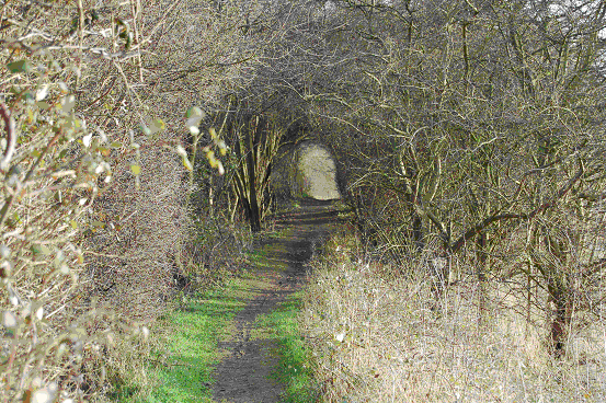
 The canal bed can easily be followed through Uffington park.
|
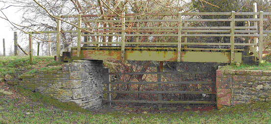
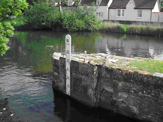
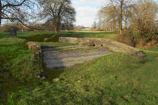
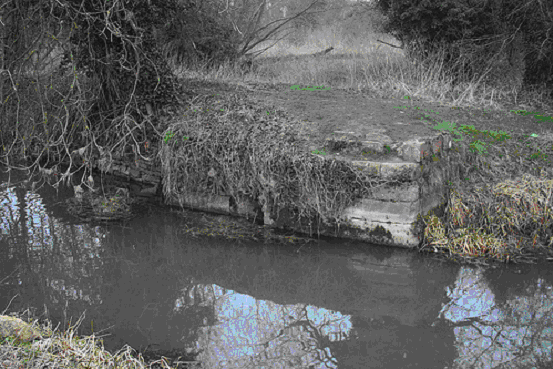
 Briggins lock in Deeping is the most complete of the remaining structures.
|
Low locks in Deeping St
James.
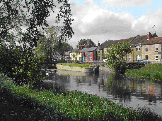
From here the Welland was navigable to the sea, some 34 miles in
total.
By 1860 the canal was getting impossible to navigate. In 1863 the canal was used for the last time.
| Location | Ordnance Survey Map Reference | Stamford Canal Miles/Yards | River Welland Miles/ Yards |
| Stamford, High Street Bridge | 03060694 | 0 : 0 | |
| Footbridge | 03360693 | 0 : 330 | |
| Junction of the canal and the river, east of Stamford | 04140737 | 0 : 0 | 0 : 1350 |
| Hudd's Mill Lock No 1 (Top Lock) | 042074 | 0 : 150 | |
| Accommodation Bridge (access to Hudd's Mill) | 042075 | 0 : 175 | |
| River Gwash Crossing | 04830763 | 0 : 775 | 1 : 420 |
| Uffington Stone Bridge (road to Barnack) | 06640794 | 1 : 1320 | 2 : 650 |
| Copthill Farm West Lock No 2 (Copthill Upper Lock) | 073072 | 2 : 460 | |
| Copthill Farm East Lock No 3 (Copthill Lower Lock) | 077073 | 2 : 1025 | |
| Copthill Turnpike Lock No 4 (West Marsh Lock) | 083077 | 3 : 80 | |
| Tallington Village Lock No 5 | 992080 | 3 : 850 | |
| Tallington Crossing (ford - road to Bainton) | 09240794 | 3 : 1005 | 3 : 1640 |
| Tallington Horse Holmes Lock No 6 | 098083 | 3 : 1600 | |
| Railway Crossing - Great Northern Railway from Peterborough | 09870832 | 3 : 1690 | 4 : 710 |
| St. Andrews Lock No 7, West Deeping | 109087 | 4 : 1310 | |
| West Deeping Crossing (ford - King Street - Roman Road) | 11010872 | 4 : 1480 | 5 : 470 |
| Eastfield Lock No 8 West Deeping (Lammas Close Lock) | 118093 | 5 : 1295 | |
| Molecey's Lock No 9 (Molecey Mill Lock) | 124098 | 6 : 250 | 6 : 790 |
| Greatford Drainage Cut enters from the north | 12610987 | 6 : 415 | 6 : 960 |
| A 15 Bridge (Deeping Bypass - modern) | 13040982 | 6 : 935 | 6 : 1430 |
| Thorpe's Lock No 10, Market Deeping (Market Deeping Mill Lock) | 13400990 | 6 : 1340 | 7 : 85 |
| Tongue End, end of Stamford Canal which rejoins the Welland | 13600990 | 6 : 1540 | 7 : 275 |
| Market Deeping Bridge (B.1524 former A5 Lincoln Road) | 13860986 | 7 : 620 | |
| Briggin's Lock No 11, Deeping Gate (lock extant & footbridge) | 14830957 | 7 : 1730 | |
| Deeping Gate Bridge (B 1162 road to Northborough) | 15060951 | 8 : 240 | |
| Footbridge | 15120948 | 8 : 310 | |
| Deeping Low Lock No 12, Deeping St. James | 16410901 | 9 : 270 | |
| Railway Bridge - Peterborough to Spalding & Boston | 17530737 | 10 : 500 | |
| Junction with the Maxey (Drainage) Cut | 17730738 | 10 : 950 | |
| Junction with the Folly River | 17980753 | 10 : 1270 | |
| Junction with arm towards Borough Fen | 21260951 | 13 : 310 | |
| Junction with former arm to Crowland | 22971061 | 14 : 780 | |
| Fen Bridge, Crowland (B.1166) | 22951064 | 14 : 830 | |
| Four Mile Bar Footbridge (near St. Guthlac's Cross) | 25621527 | 18 : 90 | |
| Spalding Southern Bypass Bridge (A.16) | 23791924 | 20 : 1740 | |
| Junction with New River Drain (New River Outfall) | 24252121 | 22 : 730 | |
| Little London Bridge (linking the B.1172 and B.1173) | 24292129 | 22 : 830 | |
| Railway Bridge (former Spalding to March line) | 24442158 | 22 : 1200 | |
| Entrance to the Coronation Flood Channel | 24502171 | 22 : 1370 | |
| New Footbridge | 24642193 | 22 : 1630 | |
| Site of former railway bridge (Spalding to King's Lynn line) | 24642195 | 22 : 1670 | |
| High Bridge, Spalding | 24862253 | 23 : 650 | |
| Albion Street, Spalding | 25002278 | 23 : 920 | |
| Footbridge | 25182303 | 23 : 1310 | |
| Footbridge | 25202308 | 23 : 1350 | |
| West Elloe Bridge (A.151 - roundabout with adjoining bridge) | 25532355 | 24 : 190 | |
| West Elloe Bridge (A.151 - roundabout with adjoining bridge) | 25532355 | 24 : 230 | |
| Fulney Tidal Lock | 25812403 | 24 : 830 | |
| Coronation Flood Relief Channel rejoins the Welland | 25912421 | 24 : 1060 | |
| Spalding Northern Bypass bridge (A.16) | 26383527 | 25 : 1150 | |
| Junction with Vernatt's Drain (Vernatt's Outfall) | 28252936 | 28 : 800 | |
| Junction with River Glen, Surfleet Seas End | 28252950 | 28 : 920 | |
| Junction with Lord's Drain | 29553077 | 29 : 1280 | |
| Junction with Risegate Eau Drain (Risegate Outfall) | 30373161 | 30 : 790 | |
| Fosdyke Bridge (A.17 - replacing former moveable span) | 31873223 | 31 : 840 | |
| Greenwich Meridian | 34553475 | 33 : 940 | |
| The Wash (District Council boundary) | 36463538 | 34 : 1710 | |
| Lot | From | To | Yards |
| 1 | First gate east of Hudd's Mill | River Gwash crossing | 625 |
| 2 | East side of river Gwash | Uffington Stone Bridge | 2305 |
| 3 | Uffington Stone Bridge past two locks | Fence at the bend of the canal | 2006 |
| 4 | East end of Lot 3 including the lock | Deeping & Morcott turnpike road | 245 |
| 5 | East end of Lot 4 | Not specified - alongside turnpike road | 100 |
| 6 | East end of Lot 5 | Not specified - alongside turnpike road | 100 |
| 7 | East end of Lot 6 | Not specified - alongside turnpike road | 100 |
| 8 | East end of Lot 7 | Not specified - alongside turnpike road | 100 |
| 9 | East end of Lot 8 | Not specified - alongside turnpike road | 100 |
| 10 | East end of Lot 9 | Not specified - alongside turnpike road | 160 |
| 11 | East end of Lot 10 | Not specified - alongside turnpike road | 147 |
| 12 | East end of Lot 11 | Tallington Stone Bridge | 147 |
| 13 | Tallington Stone Bridge | Tallington Foot Bridge | 344 |
| 14 | Tallington Foot Bridge | West side of Great Northern Railway | 448 |
| 15 | West side of Great Northern Railway | West Deeping Bridge | 1552 |
| 16 | West Deeping Bridge | Foot bridge in West Deeping | 201 |
| 17 | Foot bridge in West Deeping | West end of Lot 18 | 1415 |
| 18 | East end of Lot 18 | West end of Lot 19 including lock | 676 |
| 19 | East end of Lot 18 | Not specified - alongside turnpike road | 421 |
| 20 | East end of Lot 19 | Not specified - alongside turnpike road | 415 |
| 21 | East end of Lot 20 | The Tongue End, Market Deeping | 345 |
| 22 | Land between the Welland and the Lower Locks in Deeping St.
James (Includes Lower Lock) |
||
| 23 | Briggin Lock, Deeping St James | ||
| 24 | River Gwash masonry & iron sluice doors |
The right hand table has been created using modern Ordnance Survey Explorer maps (Rutland Water - 15; Wisbech & Peterborough North - 235) and map measurement.
Allowing for the different starting point of the two tables there is a difference between them of 855 yards at the Deeping Bypass Bridge. This has not yet been resolved but seems more likely to lie in the canal table owing to the incomplete information available. Amendments and additions to this list and any general comments would be welcomed.
Eight digit Ordnance Survey map references have been given where possible, particularly downstream from the Deeping Bypass Bridge as places can be accurately identified. As it is difficult to determine the precise position of several of the canal locks, six digit
A book called 'The Stamford Canal' Published by Deepings Heritage is a very worthy read.
| The Stamford Canal (Paperback) by Keith Reginald Simpson
(Editor) Price: £6.00 & eligible for Free UK delivery on orders over £15 with Super Saver Delivery. See details and conditions Availability: Temporarily out of stock. Order now and we'll deliver when available. We'll e-mail you with an estimated delivery date as soon as we have more information. Your account will only be charged when we ship the item. Dispatched from and sold by Amazon.co.uk. |
| The East Anglian Waterways Association is a believer in "Waterways for All" - promoting access to our navigations for the community - whether walkers, nature lovers, anglers, canoeists, boaters or gongoozlers. We work with and support many local societies, trusts and other user bodies in the area - Please visit our LINKS page for more information. |
| ©2013 - East Anglian Waterways Association Limited - Reg. 895405 - Registered Charity No. 251382 |